
- Location
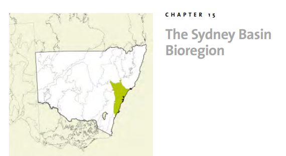
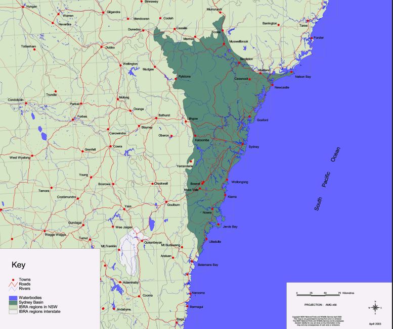
The Sydney Basin Bioregion lies on the central east coast of NSW and covers an area of approximately 3,624,008 ha (IBRA 5.1). It occupies about 4.53% of NSW and is one of two bioregions contained wholly within the state. The bioregion extends from just north of Batemans Bay to Nelson Bay on the central coast, and almost as far west as Mudgee. The bioregion is bordered to the north by the North Coast and Brigalow Belt South bioregions, to the south by the South East Corner Bioregion and to the west by the South Eastern Highlands and South Western Slopes bioregions.
As well as Sydney itself, the Sydney Basin Bioregion encompasses the towns of Wollongong, Nowra, Newcastle, Cessnock, Muswellbrook and Blue Mountains towns such as Katoomba and Mt Victoria.
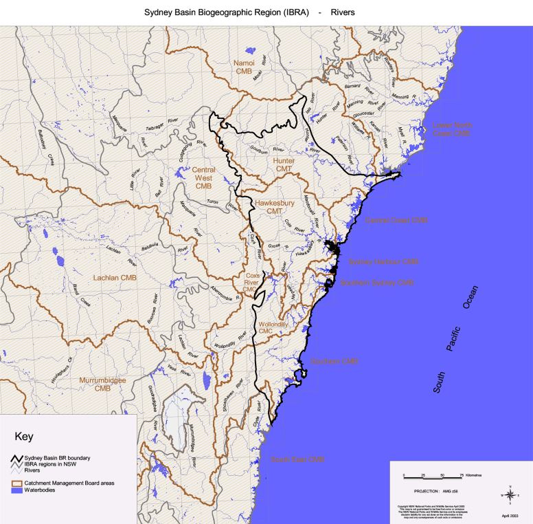
It includes a significant proportion of the catchments of the HawkesburyNepean, Hunter and Shoalhaven river systems, all of the smaller catchments f Lake Macquarie, Lake Illawarra, Hacking, Georges and Parramatta Rivers,
and smaller portions of the headwaters of the Clyde and Macquarie rivers.
2. Climate
The Sydney Basin Bioregion is dominated by a temperate climate characterised by warm summers with no dry season. A sub-humid climate occurs across significant areas in the northeast of the bioregion. A small area
in the west of the bioregion around the Blue Mountains falls in a montane climate zone. Snow can occasionally occur in this area of higher elevation.
Rainfall can occur throughout the year, but varies across the bioregion in relation to altitude and distance from the coast, with wetter areas being closer to the coast or in higher altitudes.
Temperature varies across the bioregion, with areas of higher temperature occurring along the coast and in the Hunter valley and areas of lower temperature on the higher plateaux and western edge.

- Topography
The Sydney Basin Bioregion lies on the east coast and covers a large part of the catchments of the Hawkesbury-Nepean, Hunter and Shoalhaven river systems. It consists of a geological basin filled with near horizontal sandstones and shales of Permian to Triassic age that overlie older basement rocks of the Lachlan Fold Belt. The sedimentary rocks have been subject to uplift with gentle folding and minor faulting during the formation of the Great Dividing Range. Erosion by coastal streams has created a landscape of deep cliffed gorges and remnant plateaus across which an east-west rainfall gradient and differences in soil control the vegetation of eucalypt forests, woodlands and heaths. The Sydney Basin Bioregion includes coastal landscapes of cliffs, beaches and estuaries. - Geology and geomorphology
The Sydney-Bowen Basin was formed when the earth’s crust expanded, subsided and filled with sediment between the late Carboniferous and Triassic. Early stages of development were as a continental rift that filled with marine volcanic sediments, but deposition shifted to river and swamp environments in a cold climate in the early Permian. Coal deposits accumulated and the upper parts of the basin were covered in quartz sandstone by extremely large braided rivers whose headwaters lay hundreds or even thousands of kilometres away and flowed in from the south and the northwest to deposit the Hawkesbury Sandstone. Shallow marine sediments and later more river sediments continued to accumulate in the basin during
the Jurassic but all of these younger rocks have been eroded, leaving only a thin cap of shale over the resistant sandstones.
At a late stage in the basin filling, older rocks of the New England Fold Belt were faulted across the basin along the Hunter-Mooki-Goondiwindi Thrust System that now marks the northeastern edge of the bioregion. The basin has also been subject to minor volcanic activity with more than 200 explosive vents (diatremes) and small basalt flows evident in the geology.
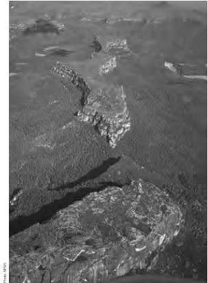
As in most parts of the Great Dividing Range, the most spectacular mountain landscape is found on the coastal side of the divide along the Great Escarpment where streams have eroded deep gorges and cliff faces back into the uplifted block. The frontal slope of the Blue Mountains is formed along the Lapstone monocline. A secondary flexure and similar escarpments occur at the coast forming the Hornsby Plateau and the Illawarra escarpment. These structural features combine with different rock types and strong trends
in joint patterns to control drainage patterns and the distribution of gorges and swamps. Much of the Basin landscape is elevated sandstone plateau, with the exceptions being the Hunter Valley and the low-lying Cumberland Plain. In the south and west the Basin ends in cliff lines formed on sandstones and conglomerates of the basal Permian sediments. Waterfalls are common on all escarpments.
The post-glacial rise in sea level between 18,000 and 6,000 years ago drowned the coastal plains and river valleys to form estuaries and deep harbours now fronted by confined barrier systems of beaches, dunes and
coastal lakes. Barriers have best developed at Newcastle, Kurnell and Jervis Bay and some of these areas include “cliff top” dunes that often enclose swamps and lakes formed by groundwater - Geodiversity
The most significant feature of the bioregion is:
– the Great Escarpment, easily the most prominent feature of the bioregion, with its reversed drainage, and entrenched meander patterns and high level terrace gravels; the Blue Mountains are part of this feature.
At a smaller scale many interesting landscapes are present, including the
following:
– the Pagoda country on deeply weathered sandstones on gorge edges;
– the gorges themselves;
– contour-patterned vegetation communities on alternating sandstones and shale plateaus;
– the concentration of volcanic vents or diatremes are significant on a world scale and these features always carry locally different vegetation;
– coastal barriers, deep estuaries and spectacular cliffs with exposed “layer cake” geology and well-developed rock platforms;
– Sydney Basin coal resources are economically critical to the state; and
– several geologic features of importance to Aboriginal people, including cultural sites of prominent landscape features, stone resources in terrace gravels and basalt outcrops, stone carving and axe grinding sites on sandstone and sandstone rock shelters. - Soils
The considerable range of rock types, topography and climates in the Sydney Basin has resulted in a large variety of soils and vegetation communities.
The coastal area of the bioregion consists of frontal dunes. Dunes behind this accumulate organic matter and begin to develop coloured subsoil. The oldest dunes on the inland side of the barrier and the parabolic dunes high in the landscape, even on headlands, have well-developed podsol profiles.
Limited areas of rainforest can be found in the lower Hunter, Illawarra escarpment and on Robertson basalts, as well as in the protected gorges and on richer soil in most subregions.
Species composition and structural form are similar on sandy soils of the sandstone plateaus and the sandy soils of the dunes. Better quality shale soils form caps on sandstone and on the coastal ramps. - Biodiversity
7.1 Plant communities
The Sydney Basin Bioregion is one of the most species diverse in Australia. This is a result of the variety of rock types, topography and climates in the bioregion.
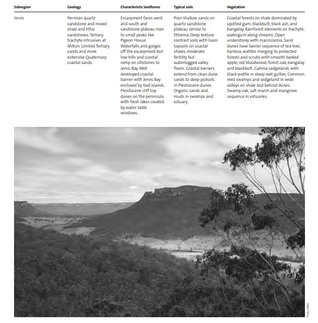
The frontal dunes along the coastal area of the bioregion supports coast teatree (Leptospermum laevigatum), coast wattle (Acacia longifolia) and coast banksias (Banksia aemula, B. serrata, B. integrifolia), often with grass tree (Xanthorroea sp.) and lomandra (Lomandra longifolia). Dunes generally support vegetation communities dominated by old man banksia (Banksia serrata), smooth-barked apple (Angophora costata), red bloodwood (Corymbia gummifera) and blackbutt (Eucalyptus pilularis) with a diverse shrub layer. The oldest dunes, which lie on the inland side of the coastal barrier or are found
as parabolic dunes high in the landscape, such as on headlands, support a mature coastal forest community.
Estuaries are characterised by a swamp oak (Casuarina glauca), common reed (Phragmites australis), saltmarsh (Juncus kraussii, Sporobulus virginicus, and Sarcocornia quinqueflora) and mangrove (Aegiceras corniculatum and Avicennia marina) sequence. The boundaries of these communities are dynamic due to present day geomorphic processes.
Rainforest communities are characterised by coachwood (Ceratopetalum apetalum), native tamarind (Diploglottus australis), white cherry (Schizomeria ovata), cheese tree (Glochidion ferdinandi), lilly pilly (Acmena smithii), blackwood (Acacia melanoxylon) and Port Jackson fig (Ficus rubiginosa), with soft tree fern (Dicksonia antarctica) and rough tree fern (Cyathea australis) common in the understorey. The adjacent tall forests are dominated by Sydney peppermint (Eucalyptus piperita), narrow-leaved peppermint (Eucalyptus radiata), messmate (Eucalyptus obliqua), brown barrel (Eucalyptus fastigata), yellow stringybark (Eucalyptus muellerana), coastal white box (Eucalyptus quadrangulata), blackbutt, turpentine (Syncarpia glomulifera), Deane’s gum (Eucalyptus deanei), bangalow palm (Archontophoenix cunninghamiana), cabbage tree palm (Livistonia australis), forest oak (Allocasuarina torulosa) and the creekline species, water gum (Tristania laurina).
Species composition and the structural form of the vegetation communities occupying extensive sandstone plateaus vary with altitude and rainfall. Common trees include red bloodwood, yellow bloodwood (Corymbia eximia), rough-barked apple (Angophora floribunda), smooth-barked apple, hardleaved scribbly gum (Eucalyptus sclerophylla), grey gum (Eucalyptus punctata), black ash (Eucalyptus sieberi), Sydney peppermint, blue-leaved stringybark (Eucalyptus agglomerata), turpentine, brown stringybark (Eucalyptus capitellata) and northern grey ironbark (Eucalyptus siderophloia).
Drier, lowland environments, such as the upper Hunter, Cerrabee and Cumberland Plain support forests and woodlands dominated by forest red gum (Eucalyptus tereticornis), grey gum, spotted gum (Eucalyptus maculata), scribbly gum (Eucalyptus haemastoma), grey box (Eucalyptus moluccana), white box, yellow box (Eucalyptus melliodora), fuzzy box (Eucalyptus conica), narrow-leaved ironbark (Eucalyptus crebra), broad-leaved ironbark (Eucalyptus fibrosa), rough-barked apple, yellow bloodwood and extensive stands of swamp oak.
Riparian vegetation is dominated by river oak (Casuarina cunninghamiana) through most of the basin, with river red gum (Eucalyptus camaldulensis) occurring in the Hunter and water gum occupying the wetter, more protected
environments.
Swamp vegetation ranges from monocultures of common reed to complex prickly-leaved tea-tree (Melaleuca stypheloides) and paperbark (Melaleuca quinquenervia) associations, with swamp mahogany (Eucalyptus robusta), swamp oak, sedges, tall spike rush (Elaeocharis sphacelata) and juncus (Juncus sp.) Hanging swamps can be found on sandstone and dunes, with the dominant species being gahnia (Gahnia aspera) and banksia (Banksia robur). A raised sphagnum bog (Sphagnum sp.) is located at Wingecarribee, an uncommon vegetation community in the Sydney Basin.
Coastal forest characterised by Sydney blue gum (Eucalyptus saligna), blackbutt, turpentine, grey ironbark (Eucalyptus paniculata), spotted gum, black ash and bangalay (Eucalyptus botryoides) occupies shale-derived soils capping sandstone and along parts of the coastal ramp. These often have an open understorey, with macrozamia (Macrozamia communis) and cabbage tree palm.
7.2 Significant flora
Wollemi National Park, the largest reserve in the bioregion, protects many threatened species as well as species whose distribution is restricted entirely to the bioregion. Such flora species include Apatophyllum constablei, Acacia asparagoides, Eucalyptus bensonii and Rupicola decumbens, all of which are locally endemic (NSW NPWS 2002). The recently discovered Wollemi Pine (Wollemia nobilis) occurs only in a very restricted part of the bioregion. It is a relict of the Gondwanan era (60-200 million years ago) found in a remote canyon in Wollemi National Park (NSW NPWS 2002). It is now listed as endangered in the TSC Act.
Important vegetation communities include yellow box – ironbark woodlands in the northern escarpments of the bioregion. These woodlands are thought to provide important habitat for species such as the regent honeyeater (Xanthomyza phrygia), but are not well represented in conservation reserves in the bioregion (NSW NPWS 2002). Mellong Swamp in the Wollemi National Park is another unique plant community, which provides important habitat for both reptiles and invertebrates in the bioregion (NSW NPWS 2002).
In total there are 92 vulnerable and 60 endangered plant species in the bioregion (Australian Terrestrial Biodiversity Assessment 2002).
7.3 Significant fauna
Threatened species recorded in the bioregion include the brush-tailed rock wallaby (Petrogale penicillata), koala (Phascolarctos cinereus), yellow-bellied glider (Petaurus australis), brush-tailed phascogale (Phascogale tapoatafa), tiger quoll (Dasyurus maculatus), broadheaded snake (Hoplocephalus bungaroides), glossy black cockatoo (Calyptorhyncus lathami), turquoise parrot (Neophema pulchella) and powerful owl (Ninox strenua) (NSW NPWS 2002).
The Sydney Basin Bioregion is home to 2 endangered and 4 vulnerable frog species, 54 vulnerable and 14 endangered bird species, 25 vulnerable, 3 endangered and one extinct mammal species, and 11 vulnerable and 2 endangered reptile species.
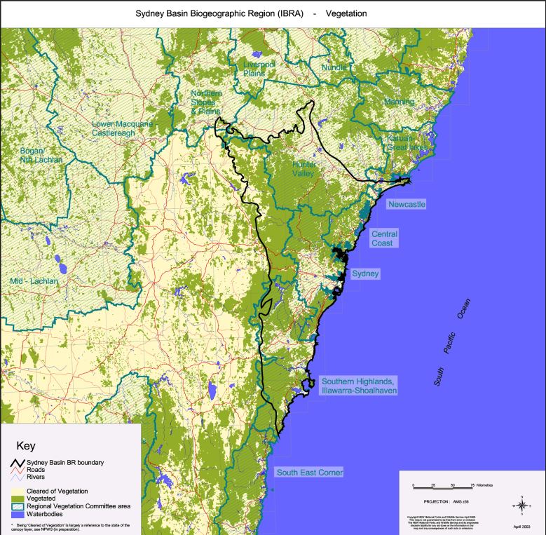
Although the Sydney Basin Bioregion has the highest human population of any NSW bioregion, significant areas of native vegetation remain unchanged since European occupation. Despite this, significant rates of decline of
grassland, woodland and forest bird species, as well as ground-nesting birds and ground-feeding insectivorous birds, have occurred in this bioregion. Sightings of rainforest birds, which increased significantly across Australia, did not follow this trend in the Sydney Basin despite the presence of areas of relatively intact rainforest (Australian Terrestrial Biodiversity Assessment 2002). Sightings of the rockwarbler (Origma solitaria), a species largely restricted to the bioregion, have been reported less frequently than in the past. Loss of forest and woodland birds around Sydney, resulting from continuing urbanisation, is a threat now and into the future (Australian Terrestrial Biodiversity Assessment 2002).
Despite declines in some native species, others such as the white-headed pigeon (Columba leucomela), spotted turtle-dove (Streptopelia chinensis), long-billed corella (Cacatua tenuirostris), little corella (Cacatua sanguinea), rainbow lorikeet (Trichoglossus haematodus) and noisy miner (Manorina melanocephala) as well as the introduced red-whiskered bulbul (Pycnonotus jocosus) and common myna (Acridotheres tristis) seem to have increased in numbers in the bioregion (Australian Terrestrial Biodiversity Assessment 2002). This is probably a result of their ability to adapt well to environments modified by humans.
Two threatened species listed in the NSW TSC Act, the ground parrot (Pezoporus wallicus) and the eastern bristlebird (Dasyornis brachypterus), have both been recorded southwest of Wollongong and near Jervis Bay in the bioregion’s south, while the largest population of the endangered regent honeyeater (Xanthomyza phrygia) has been recorded in the north of the bioregion around the Capertee Valley. Forest and woodland birds of the
bioregion are thought to be somewhat protected in Hawkesbury sandstone communities contained in conservation reserves (Australian Terrestrial Biodiversity Assessment 2002).
General threats to species in the bioregion include broad-scale vegetation clearing and loss of remnants as well as grazing by stock. Urbanisation is also a major threat to many species in the built-up areas in the bioregion.
7.4 Significant wetlands
Nine wetlands in the Sydney Basin Bioregion are regarded as being bioregionally significant (Australian Terrestrial Biodiversity Assessment 2002).
Swan Lake provides important breeding habitat for prawns and fish and is a key feeding and roosting area for waterfowl. The lake also supports an extensive area of seagrass (Halophila ovalis and H. decipiens) (Australian
Terrestrial Biodiversity Assessment 2002).
Lake Conjola provides nesting habitat for a number of threatened shorebirds. These include the endangered little tern (Sterna albifrons) and hooded plover (Thinornis rubricollis) as well as the vulnerable pied oystercatcher
(Haematopus longirostris). The lake also supports a significant area of seagrass (Zosteraceae and Halophila) (Australian Terrestrial Biodiversity Assessment 2002).
Lake Liddell supported over 2,000 waterbirds in 1985 and over 3,000 waterbirds in 1995 (Australian Terrestrial Biodiversity Assessment 2002). The most abundant species in 1985 were Eurasian coot and black swan (Cygnus atratus). In 1995, the most abundant species were Eurasian coot (Fulica atra), little black cormorant (Phalacrocorax sulcirostris), great cormorant (Phalacrocorax carbo) and little pied cormorant (Phalacrocorax
melanoleucos). The vulnerable freckled duck (Stictonetta naevosa) (NSW NPWS 2001) and the endangered green and golden bell frog (Litoria aurea) have both been recorded at the lake.
North Avoca Swamp has also been described as bioregionally significant as it provides key habitat for the endangered green and golden bell frog (Australian Terrestrial Biodiversity Assessment 2002).
Narrabeen Lagoon and Deep Creek support the vulnerable black bittern (Ixobrychus flavicollis), Australasian bittern (Botaurus poiciloptilus), osprey (Pandion haliaetus) and glossy black cockatoo (Calyptorhynchus lathami) (Australian Terrestrial Biodiversity Assessment 2002).
Bakers Lagoon supports a range of important species including the vulnerable freckled duck, Australasian bittern (Botaurus poiciloptilus), blacktailed godwit (Limosa limosa) and black bittern (Ixobrychus flavicollis). There have also been sightings of a star finch (Neochmia ruficauda) at the Lagoon, a species that is classified as extinct under the TSC Act, as well as the endangered black-necked stork (Ephippiorhynchus asiaticus).
The wetlands of the Cecil Hoskins Nature Reserve are considered to be bioregionally significant. They are described as being in fair condition, although feral animals, exotic weeds, changed hydrology, and pollution due to runoff from agricultural lands threaten their status.
Brundee Swamp provides key habitat for the vulnerable Australasian bittern. Disturbances and threats to the wetlands in the Sydney Basin Bioregion are many and varied depending on their location and include impacts from urban, agricultural and industrial development.
Decreased water quality in the wetlands results from runoff from urban areas, industrial areas, agricultural lands and rubbish tips, as well as increased stormwater and pollution from sewage treatment works. Potential spills from shipping and industries can also pose a serious risk to wetland health.
The bioregion is densely populated and pressures from recreational activities, including horse riding, jetskis and boats, fishing, erosion caused by the wash from speedboats, erosion from walking and access tracks, can threaten the biodiversity of the wetlands.
Other threats include feral animals and exotic weeds, changed fire regimes, sedimentation, salinity, weir construction and mining activities.
Regional history
8.1 Aboriginal occupation
Several distinct indigenous groups occupied the Sydney Basin when the First Fleet arrived in 1788. The largest of these groups were the people of the Dharug language group, although it is uncertain that this is the name they called themselves, and alternative spellings include Dharuk and Dharook (Murray and White 1988). The Dharug language group consisted of two dialects, one which was used east of Parramatta and between Sydney Harbour and Botany Bay, and the other which was spoken in the west to the Hawkesbury, Blue Mountains and Nepean districts (the latter known as Muru-Murak or “mountain pathway”). A third group to the north of Sydney Harbour spoke the Kuringai language, while the Dharawal language region occurred from the Botany Bay south to Jervis Bay (Murray and White 1988).
The coast of the Sydney Basin Bioregion, as well as the coastlines of the other two coastal bioregions in NSW, offered a variety of environments between the sea and the ranges that were used by the Aboriginal people of the area (NSW NPWS 1980). The range of environments bore a profound influence of the lives of the Sydney Basin Aborigines. As hunters and gatherers they were reliant on their surroundings to provide food and this lifestyle affected the population size, social interactions and degree of mobility of the groups (NSW NPWS 1980). Around Sydney itself, food availability, especially fish and shellfish gathered from the sea, changed seasonally and was more reliable in summer than in winter. Further inland Aboriginal people relied on possum, vegetable roots, seeds and berries as well as mullet, eel and kangaroo (Murray and White 1988).
The Aboriginal population for the Sydney region in 1788 has been estimated as being between 5,000 and 8,000 people, of which about 2,000 belonged to the inland Dharug people: 1,000 between Parramatta and the Blue
Mountains and 1,000 between what are now Liverpool and Campbelltown (Murray and White 1988). The Dharug people were thought to have lived in bands or communities of around 50 members each. Each band retained its
own hunting district, and each lived a semi-nomadic lifestyle, regularly changing location within this district (Murray and White 1988). Typical dwellings were two-sided bark tents known as gunyahs throughout NSW,
while sandstone rock shelters were used in harsh weather. Men of the communities were responsible for hunting possums, fish, birds and kangaroo, often collaborating with other bands to hunt and eat the larger animals. Fire
was used to reduce undergrowth and to catch game. Dharug women harvested what the Europeans called yams (the community’s staple) with digging sticks. Food was cooked lightly on open fires or in ovens beneath the ground.
The religion of the Dharug people took the form of a deeply spiritual association with the land and was evident in singing, dancing and stories as well as the many engravings on the flat sandstone outcrops of the Sydney
Basin, some of which have remained for thousands of years. The dialects of the Dharug language were fairly complex with a rich vocabulary and grammar complete with numerous tenses. Australian English reflects the influence of Dharug people on the culture of the Sydney Basin in words such as boomerang, corroboree, dingo, koala, kookaburra, wallaby and the bush call coo-ee, which were all derived from Dharug languages.
The arrival of Europeans to the country of the Dharug people in 1788 had swift and often devastating effects on the indigenous population of the Sydney Basin. The impact was so rapid that many records and stories of the
people were lost early on. Violence and the destructive effects of a small pox epidemic wiped out most of the coastal people and soon after spread to the inland Dharug communities around the Hawkesbury-Nepean area. Those who survived the epidemic that decimated much of the Dharug group went on living a semi-traditional life, often on the boundaries of European settlement (Murray and White 1988) or continued hunting on the estates that were formerly their country, supplementing their supplies with those of the new settlers. Despite this subsistence, Aboriginal numbers continued to decline and by 1827 the estimated population of 156 was around a third less than that estimated in 1788 and still declining as couples often did not have children (Murray and White 1988).
Further north in the bioregion, at the very tip where it meets the Brigalow Belt South Bioregion at what is now Towarri National Park, lay the traditional country of the Wonnarua people. The boundaries of this country, mainly in the Upper Hunter, is said to have bounded land that now includes the towns of Muswellbrook, Singleton and Scone, spanning north to Murrurundi and south to Newcastle and encompassing the upper northeast of the bioregion.
The patterns of land use undertaken by the Wonnarua differed little from those of the indigenous people in the rest of the Sydney Basin. Foods were gathered from the land and the rivers and both of these provided a rich variety of resources to the local community. Like their southern counterparts, the culture of the Wonnarua people was closely linked to their natural environment and stories, like the one below told by Tom Miller of the Wonnarua people, described the formation of the landscape (Veale 2001):
“When a group of warriors set out for a long journey to Broke Flats for a battle with the Kamilaroi, they left behind the old people, women and children. After the fight the remaining warriors returned to their camp.
There was one girl that sat waiting and waiting for her man to return. When he didn’t return she prayed to Biami to come and take her life because she could not carry on without her fellow. Biami felt sorry for the girl that never stopped crying for her man and made her into a stone feature looking down on the valley. She is still there today as part of the Wingen Maid, and the tears she cried fell upon Burning Mountain and ignited the fire that is still burning today.” (Veale 2001)
8.2 European occupation
After the initial discovery of Botany Bay in 1770, the First Fleet arrived at this shallow bay in January 1788. Governor Arthur Phillip found that Botany Bay was not a suitable location for a colony, moving the fleet further north to Port Jackson (NSW NPWS 1991) where he founded the colony at Sydney Cove. The Tank Stream was dug early on, providing a source of fresh water for the colony (HO and DUAP 1996) and soon the population of about 1,000 people lived at Sydney Cove in tents, huts or wattle and daub houses (HO and DUAP 1996).
Within a year the newly settled population had more than doubled, reaching 2,500, a rise due mainly to the transportation of convicts to the colony (HO and DUAP 1996). By this time another settlement had begun on the fertile land at Parramatta and former convicts were farming the rich alluvial land near the Hawkesbury, much to the opposition of the local Aboriginal people (HO and DUAP 1996).
Port Jackson (Sydney Harbour) held a significant place in the colony throughout the nineteenth century. It was an entry point for convicts, supplies and free settlers while goods produced by the new colony sailed out
of the heads (NSW NPWS 1991). Wool, timber, gold and whale and seal products were all exported from Port Jackson at one time or another (NSW NPWS 1991).
Convicts or immigrants entering the harbour and suspected of carrying disease were, along with their ships, quarantined away from the populated areas (NSW NPWS 1991). One such place was North Head, which was used as a quarantine station for over 100 years. Fortifications were built on the major headlands to protect the harbour against attacks (NSW NPWS 1991).
The harbour provided an important means of communication. The upper reaches led to the Parramatta River, which became a vital link between the port and the farming lands in the west. Goods and people alike were transported to and from the fertile farming areas around the western town (NSW NPWS 1991).
On the south side of the harbour, transport on a rutted track along the Parramatta River allowed settlement to proceed to the west as well as south along the Cooks and Georges Rivers flowing into Botany Bay (NSW NPWS 1991). The 1820s saw the occupation of most of this land and settlers on smaller lands were forced further west by the occupation of large land holdings at Annandale, Petersham and Ultimo (NSW NPWS 1991).
The early Sydney was a wooden town replaced in time by grander, more permanent buildings (HO and DUAP 1996). Between 1810 and 1821 Governor Macquarie, with help from architect Francis Greenway, was responsible for the construction of some very grand buildings, some of which, such as the Mint Building and NSW Parliament House, still survive (HO and DUAP 1996).
In the early days of Sydney most of the colony’s expenditure came from the Crown with few exports except for cedar, which was exported from 1806. However, it was in the 1820s that the new and profitable industry was discovered (HO and DUAP 1996). The hunting of whales and seals was at first a lucrative business, with shipping directly to England after the monopoly held by the East India Company was broken. When resources were drained, whaling ships were sent towards New Zealand. The shipping industry was also lucrative during the early 1800s, with so many ships leaving and arriving at Port Jackson that there began a significant market in shipping supplies. Wool also became a significant industry, and was shipped from Port Jackson, increasing the harbour’s trade (HO and DUAP 1996). It was in the early to mid1800s that the market for consumer goods was realised and the colony began processing many of its own goods, from candles and sugar, to flour, beer, pottery and bricks (HO and DUAP 1996).
The suburbs on the southern side of Sydney town developed more quickly due to ease of transport, assisted by the construction of the railway in the 1850s. Tramways constructed during the 1880s were also a factor in the development of inner suburbs. Harbour crossings by road and railway began to link the two sides of the harbour.
Most of the land between the harbour and Botany Bay was increasingly used for industry, which was attracted by the water availability in the Botany swamps (NSW NPWS 1991). In addition, the industries around Sydney were under obligation to move outside the city boundaries to avoid polluting the city due to legislation passed in 1849. As industry consumed the south and east, upper-class housing moved towards the west with the railway, settling
new suburbs such as Strathfield and Summer Hill (NSW NPWS 1991).
In contrast to the bustling southern side of the harbour, the northern side remained rural and was slower to develop (NSW NPWS 1991). To the north of the harbour there were orchards and small farms with some industrial areas such as brickworks at Gore Hill in the 1870s. Many areas on the north were reliant on ferries and punts to cross the harbour or the river (NSW NPWS 1991). Governor Macquarie made an unsuccessful attempt to establish an Aboriginal farming settlement at Middle Head, named Bungarees Farm after a prominent Aboriginal man, trying in the process to “civilise” the local Aborigines (NSW NPWS 1991).
Urban development in the west was also gradual, at least initially, emerging from large farming estates used mainly for grazing and private towns on the Cumberland Plain. These were complemented by government towns such as Windsor and Narellan (HO and DUAP 1996). Parramatta, devoid of development for a long time, was considered to have become like an English country town until its eventual absorption into Sydney (HO and DUAP 1996).
The harbour remained an important resource for the people, and many feared it would become shut off to the majority of the population, with only the privileged being able to enjoy it. This prompted the government to reclaim harbour foreshores to ensure they remained in public ownership (NSW NPWS 1991). Members of the public were also concerned about the lack of public space for recreation around the new suburbs. Pushes to reserve the Lane Cove bushland around 1900 were rejected initially, but the Upper Lane Cove River area was declared parkland in 1925 (NSW NPWS 1991).
More recently, Sydney has undergone a vast population increase, and development, particularly in the west, has become rampant to cope with the increase. What were originally the far reaches of the colony have now become the outskirts of the city. Lying to the north and south of Sydney are two major coastal cities, Wollongong and Newcastle, both of which developed from industry and employed workers in steelworks run by BHP, although the
Newcastle steelworks have now closed.
- Bioregional-scale conservation
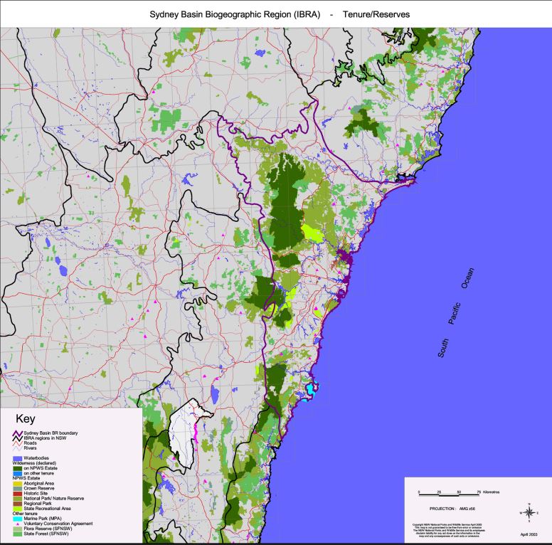
The Sydney Basin Bioregion has the third highest area of conservation oriented tenures of the NSW bioregions. Together, they occupy about 1,384,418.33 ha or 38.20% of the bioregion.
National parks and nature reserves (under the NPW Act 1974) make the greatest contribution to the area conserved, with national parks and nature reserves occupying a total area of 1,280,935.95 ha, or about 35.35% of the bioregion. Of this area, about 1,185,498 ha is also managed under the Wilderness Act 1987 and is composed of 6 wilderness areas together occupying about 559,624.92 ha or 15.44% of the bioregion. Further recognition and protection is also given to national parks in the bioregion in the area known as the Greater Blue Mountains. This has been included on the globally recognised World Heritage list as one of three world heritage areas in NSW. Occupying approximately 1.03 million ha or almost 28.42% of the
bioregion, the area is protected by international convention as well as under the Commonwealth EPBC Act 1999, which automatically protects all Australian properties that are on the World Heritage list.
Reserves under the Crown Lands Act 1989 that are managed by the National Parks and Wildlife Service contributes 1,196.23 ha to the area managed for biodiversity conservation within the bioregion.
Other lands managed under the NPW Act 1974 include: land managed as Aboriginal areas (84.80 ha or 0.002% of the bioregion); land managed as historic sites (128.34 ha or 0.004% of the bioregion); land managed as regional parks (4,675.39 ha or 0.13% of the bioregion) and land managed as state recreation areas (81,904.26 ha or 2.26% of the bioregion).
In recent years, landholders on 7 properties have entered into voluntary conservation agreements. Together the area managed permanently for conservation management occupies about 604.05 ha or 0.02% of the bioregion. Landholders on 53 properties also hold wildlife refuges, occupying 13,339.76 ha or 0.37% of the bioregion. Updated mapping (being undertaken at the time of writing) is likely to increase the area of wildlife refuges.
Landholders on 19 properties have entered into property agreements under the NVC Act (1997). The conservation zones of these agreements occupy about 386.07 ha or 0.01% of the bioregion.
Nine flora reserves under the provisions of the Forestry Act 1916 contribute towards biodiversity conservation in the bioregion, occupying about 1,163.47 ha or 0.03% of the bioregion.
Also under the provisions of the Forestry Act 1916, State forests (managed primarily for forestry activities but each with various degrees of zoning from commercial forestry to conservation), occupy about 178,066.51 ha or 4.91% of the bioregion.
Three State Environmental Planning Policies operate in the Sydney Basin Bioregion: SEPP 14 (Coastal Wetlands) (13,400.29 ha or 0.37%), SEPP 26 (Littoral Rainforests) (61.82 ha or 0.002% of the bioregion) and SEPP 58 (Protecting Sydney’s Water Supply) (570,111.54 ha or 15.73% of the bioregion).


- References
Australian Terrestrial Biodiversity Assessment 2002. National Land and Water Resources Audit, Canberra.
Heritage Office (HO) and Department of Urban Affairs and Planning (DUAP) Regional Histories: Regional Histories of New South Wales. Sydney.
Morgan, G. 2001. Delineation and description of the Eastern Environmental Subregions (provinces) in New South Wales Study. NSW National Parks and Wildlife Service, Hurstville.
Murray, R. and White, K. 1988. Dharug and Dungaree:The History of Penrith and St Marys to 1860. Hargreen Publishing Company in conjunction with the Council of the City of Penrith.
NSW NPWS 1980. A History of Aboriginal Occupation of New South Wales.
NSW National Parks and Wildlife Service, Hurstville.
NSW NPWS 1991. An Outdoor Museum: Historic places in the NSW National Parks and Wildlife Service estate. NSW National Parks and Wildlife Service, Hurstville.
NSW NPWS 2001. Atlas of New South Wales wildlife. NSW National Parks and Wildlife Service, Hurstville.
NSW NPWS 2002. Wollemi National Park Plan of Management. NSW National Parks and Wildlife Service, Hurstville.
Veale, S. 2001. Remembering Country: History and Memories of Towarri National Park. NSW National Parks and Wildlife Service, Hurstville.


Pages: 1 2