
Ku-ring-gai is one of the most bushfire prone LGAs in NSW with large tracts of bushfire prone land.
In 1994 bushfires destroying over a dozen houses in Roseville.
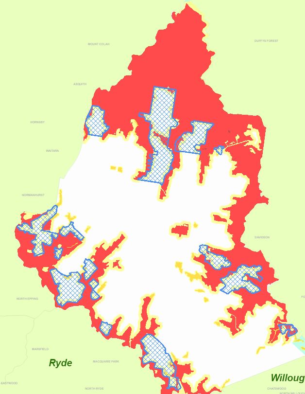
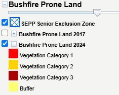
See Ku-ring-gai Council Bushfire Prone Land Map HERE or below:
Watch the Ku-ring-gai Council SimTable of Roseville Bushfire HERE
Read the TRANSCRIPT of KU-RING-GAI COUNCIL SIMTABLE OF ROSEVILLE BUSHFIRE:
Hi there. I’m Mark Schuster, Strategic Bushfire Officer with Ku-ring-gai Council.
Everyone who works or volunteers in bushfire management and response understands that no two fires are ever the same. Now with agencies such as the Australian Climate Council finding that our climate is shifting towards an increased frequency and intensity of bushfire events, impacts to local communities are expected to be much higher. As such it’s important to have a good understanding of potential bushfires and in this presentation, we’ll look at one such scenario.
Firstly, a little bit about the scenario. It’s a simulated fire run based on a number of weather and environmental factors in the Ku-ring-gai LGA. We’re only 12 kilometers as the crow flies from the Sydney GPO and the LG is surrounded on three sides – to the west, north and east by extensive bushland reserves and national parks.
Ku-ring-gai is one of the most bushfire prone LGAs in NSW with large tracts of bushfire prone land.
The 1994 bushfires impacted the area destroying over a dozen houses in the lower slopes of western Roseville, not far from where the fire simulation will be.
The bushland areas, the gully ridge systems meaning fire runs up the ridges even to where the Pacific Highway and Mona Vale Road, along the ridge tops are located.
Today you’ll see a fire progression on Council’s SimTable or simulation table.
The SimTable was developed by the US military for strategic purposes. Ku-ring-gai was the first Australian council to take up the SimTable and now it is being used by a number of other Australian councils and the Country Fire Authority in Victoria to show fire progressions. It’s an extremely valuable tool to help us with proactive planning and has been emphasized by a number of bushfire inquiries namely the Black Saturday Royal Commission and NSW Bushfire Inquiry.
Regarding the simulation. It uses three parameters to simulate a bushfire progression. The first being fuel type and load. Fuel is essential to ignite and sustain a fire. The fuel load is based on the modelling of the various vegetation types which are then translated into a fuel map which is really tonnes per hectare of fine fuels.
Topography and aspect is the next factor especially slope, steepness of the terrain and the ridges. Fire travels up ridges far more quickly in a hotter temperature than the gullies.
And possibly the most important but least predictable factor is weather. In extreme and catastrophic weather conditions where very strong winds often westerlies, very low humidity less than 20%, low soil moisture in the forest floor and these are the right conditions for a fire to ignite and form an intense fire run. Such weather conditions are predicted to be far more prevalent in the future so we must plan for these. Future fires may be very difficult to respond to.
Now let’s look at our potential scenario which we’ll watch on the SimTable.
A group of teenagers have decided to try their fire lighting skills. Almost immediately the adjoining bush is caught alight and due to the dry condition and the strong south westerly winds it is soon out of control.
Now let’s sit back and watch as both the strong winds, the fuels and the slopes do their job and the fire starts to gather momentum and moves up the slope to the east.
A big issue currently and into the future is entrapment and evacuation. Ku-ring-gai has many narrow, one way in, one way out roads. And even at the best of times with the added congestion on the ridgetop Pacific Highway it’s very hard for many residents to try and evacuate.
Can you also imagine when the fire is progressing, the panic, heavy smoke and extensive ember attack which also ignites small spot fires. They may even cause house to house ignition. Remember many of these people may have never experienced a full-blown forest fire. And are further confused by the thick smoke.
Fire and Rescue NSW and Rural Fire Service can only defend so many properties. So how do they prioritise where to go?
Now let’s look at the screen again. The bushfire front is rapidly progressing up the main bushland gully. Up the slope towards the Pacific Highway even impacting residences besides the bushland areas.
Remember it’s not just the flames at the fire front that do the damage. Nearly 90% of all the Australian house losses during fire are not from radiant heat but from embers lodging in gutters, in roof cavities, under the floors. Even landing on door mats igniting and spreading into the house.
This Roseville fire has lots of embers heading up the slope impacting houses, roads and making late evacuation very hazardous and difficult. In fact, downright dangerous.
Our fire has now reached the top of the bushland area in the critically endangered High Blue Gum Forest. Huge trees, nearly 38 metres tall and they are even lighting up. Now we are close to the Pacific Highway and adjacent Roseville rail station. And ‘Oh my God’ the heat and the embers are causing the police to close Pacific Highway stopping all evacuation. Also, NSW Rail has just closed the railway line.
Although the bushfire run has now reached its upper limit the aftermath is still going on. Heavy embers driven by the wind, small spot fires which adds to the pressure on response agencies. People are trapped on the roads, extremely frightened and bewildered. Absolute chaos.
This scenario can be avoided with good planning for the potential impact of future fires.
It’s not if but when.
And a heartfelt thank you for watching and listening today.
Thank you.